
Dettifoss Waterfall Iceland: East Side, West Side, Roads 862 and 864
- Einar Páll Svavarsson
- Apr 24
- 11 min read
Updated: Apr 25

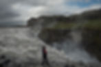
Dettifoss is one of the great natural landmarks of North Iceland. It is not the highest waterfall in the country, nor the most delicate, but few places in Iceland give such a direct impression of force. The waterfall drops from the glacial river Jökulsá á Fjöllum into Jökulsárgljúfur canyon, where the sound, spray, vibration, and scale of the landscape combine into an experience that is difficult to understand from photographs alone.
Dettifoss is usually described as Europe’s most powerful waterfall. The official Vatnajökull National Park information gives the waterfall as 44–45 meters high and about 100 meters wide, and notes that the power can even be felt through the nearby rock as the waterfall vibrates through the canyon walls.
Dettifoss is also one of the main highlights of Jökulsárgljúfur, the northern canyon area of Vatnajökull National Park. The waterfall is part of the same powerful river system as Selfoss upstream and Hafragilsfoss downstream. For visitors planning a trip in North Iceland, the most important question is usually not whether Dettifoss is worth visiting. It is. The more practical question is which side to visit, how to get there, and what conditions to expect.

Dettifoss at a glance
Dettifoss is located in Northeast Iceland, inside Vatnajökull National Park, in the Jökulsárgljúfur canyon. The waterfall is fed by Jökulsá á Fjöllum, one of Iceland’s major glacial rivers, flowing north from Vatnajökull toward the sea. The waterfall is around 44–45 meters high and about 100 meters wide. The two main access routes are Road 862 on the west side and Road 864 on the east side. Nearby waterfalls include Selfoss, about one kilometer upstream, and Hafragilsfoss, downstream in the canyon.
For most first-time visitors, the west side is usually the better and more convenient choice. For those who want a rougher, closer, and less polished experience, the east side can be excellent when Road 864 is open, and conditions are good.
Where is Dettifoss?
Dettifoss is in Jökulsárgljúfur, the great canyon carved by Jökulsá á Fjöllum in North Iceland. The waterfall lies within Vatnajökull National Park, in a remote but accessible part of the north. Many visitors include Dettifoss as part of the Diamond Circle route, often together with Mývatn, Húsavík, Ásbyrgi, Goðafoss, and other places in North Iceland.
The setting is important. Dettifoss is not an isolated waterfall in a soft green valley. It belongs to a larger landscape of basalt, glacial water, old flood channels, lava formations, barren plains, canyon walls, and powerful erosional history. The waterfall is only one part of the story. Jökulsárgljúfur itself is just as important.
Which side of Dettifoss should you visit?
Dettifoss can be visited from both the west side and the east side. The waterfall is the same, but the experience is not. The views, the road conditions, the paths, the facilities, and the feeling of the place are different.
The west side, reached by Road 862, is generally the more developed and practical side. This is the better option for most visitors, especially those traveling in a regular rental car or visiting Dettifoss for the first time. The west side has marked hiking routes, parking, toilets, and a more organized visitor experience. The official national park information describes Road 862 as the western access road and notes that it has limited winter service, meaning that conditions should still be checked carefully outside the main summer season.
The east side, reached by Road 864, is rougher and less developed. Road 864 is a gravel road, and driving can be slow. It usually closes when snow begins in autumn, and the spring opening depends on snow, mud, and drying conditions. The east side gives a more immediate and intense feeling of the waterfall, but it is not the side to choose casually in poor weather, outside the main season, or without checking current road conditions first.
If you only have time for one side, choose the west side unless you specifically want the rougher east-side experience and know the road is suitable. If you have time, good weather, and proper road conditions, visiting both sides gives a better understanding of Dettifoss. The west side gives structure and overview. The east side gives closeness and raw power.
Road 862: the west side of Dettifoss
Road 862 leads to the west side of Dettifoss. For most travelers, this is the standard route. It is the side most likely to suit families, visitors with limited time, and people who want a clear path from parking to the viewpoint.
From the west-side parking area, the walk to the Dettifoss viewpoint is about one kilometer each way, according to Vatnajökull National Park. The marked route is not difficult in normal summer conditions, but it still requires proper footwear. The ground can be wet, uneven, slippery, or icy, depending on the season and weather.
The west side is also the best starting point for the short hike to Selfoss. The Dettifoss and Selfoss trail from the west-side parking area is listed by the national park as a 2.5 km circular route, estimated at around one hour, and rated easy.
This makes the west side the most efficient choice if you want to see both Dettifoss and Selfoss in one visit.
Road 864: the east side of Dettifoss
Road 864 leads to the east side of Dettifoss. This side can be very rewarding, but it demands more caution. It is a gravel road, the drive is slower, and the route is much more dependent on seasonal conditions. The official national park information states clearly that driving on Road 864 can be slow, that it closes when snow begins in autumn, and that its reopening in spring depends on conditions, including whether wet mud has dried.
The reward is a different view of Dettifoss. On the east side, the waterfall often feels closer and more violent. The experience is less formal and less polished. For photographers, this can be useful because the east side gives a different relationship between river, canyon, mist, and falling water. But the east side should not be treated as simply another tourist stop. The road and the conditions matter.
Always check current road conditions before choosing Road 864. In Iceland, especially in the shoulder seasons, a route that looks simple on a map can be unsuitable in reality.

The power of Jökulsá á Fjöllum
The force of Dettifoss comes from Jökulsá á Fjöllum, one of Iceland’s great glacial rivers. The river originates from Vatnajökull and carries meltwater, sediment, and volcanic material northward through the landscape. This is why the water at Dettifoss is often grey, brown, or milky rather than clear. It is not a clean mountain stream. It is a glacial river carrying the story of ice, volcanic terrain, erosion, and distance.
This gives Dettifoss much of its character. The waterfall is not elegant in the same way as many other Icelandic waterfalls. It is heavy, loud, and physical. The water does not fall like a curtain. It collapses over the edge in a dense, forceful mass, sending spray into the canyon and sound through the rock.
In winter or during lower-flow periods, Dettifoss can look different from the classic summer image. In the main melt season or after periods of high water, the waterfall becomes more violent. This variability is part of the place. Dettifoss is not a fixed object. It changes with the river.
The geology of Dettifoss and Jökulsárgljúfur
The landscape around Dettifoss was shaped by both ordinary river erosion and extraordinary flood events. Jökulsárgljúfur is not simply the result of slow, gentle river carving over an immense period. Scientific research on the lower Jökulsá á Fjöllum area has shown that extreme jökulhlaup, or glacial outburst floods, played a major role in shaping the canyon landscape during the Holocene. One study describes widespread evidence of catastrophic flood action and emphasizes that extreme flood events had a dominant effect on the evolution of Jökulsárgljúfur.
This matters when visiting Dettifoss. The canyon is not only scenery. It is evidence. The large-scale forms in the landscape — the canyon walls, old flood channels, rock surfaces, boulder deposits, and the position of the waterfalls — tell the story of water moving with force far beyond ordinary river flow.
Vatnajökull National Park also explains that the large passes in Jökulsárgljúfur were shaped by outburst floods and glacial river processes over recent millennia. North of Dettifoss, the canyon narrows to about 100 meters in a short section, and the national park describes this narrow stretch as part of the ongoing work of Dettifoss cutting through the landscape.
This is one reason Dettifoss feels different from many other waterfalls. It is not only the falling water that impresses. It is the whole canyon system.
Selfoss: the waterfall upstream from Dettifoss
Selfoss is located upstream from Dettifoss and should not be skipped if conditions are good. It is lower than Dettifoss, with a drop of about 10 meters, but it has a completely different shape and mood. Instead of one massive plunge, Selfoss spreads across the river in a broad, broken formation of cascades.
The contrast between the two waterfalls is one of the best reasons to walk beyond the main Dettifoss viewpoint. Dettifoss is a force and compression. Selfoss is width, rhythm, and structure. Seen together, they show two different expressions of the same river.
From the west-side parking area, the Dettifoss and Selfoss trail is a manageable short hike in normal conditions. The national park describes the circular route as 2.5 km, about one hour, and easy.
Hafragilsfoss: the waterfall downstream
Hafragilsfoss is downstream from Dettifoss and receives less attention, partly because many visitors focus only on the famous name. That is a mistake if you have time and the conditions are favorable. Hafragilsfoss drops into a narrower part of Jökulsárgljúfur and gives another view of the canyon’s scale.
The national park gives Hafragilsfoss a drop of 27 meters. It is not as famous as Dettifoss, but it belongs to the same river system and helps visitors understand the canyon better.
For photographers and landscape-minded visitors, Hafragilsfoss can be especially interesting because it places the river more clearly within the canyon. Dettifoss is often overwhelming as a single subject. Hafragilsfoss can sometimes explain the landscape more clearly.

When is the best time to visit Dettifoss?
The easiest time to visit Dettifoss is summer, from June into early September. Roads are generally more reliable, daylight is long, and the walking routes are easier. This is also the busiest time, and the west side in particular can receive many visitors.
The shoulder seasons can be excellent, especially for photography. Late May, September, and early October may bring fewer people, lower light, snow remnants, autumn color in nearby areas, or more dramatic weather. But the shoulder seasons also bring more uncertainty. Road 864 may not be open, or may be unsuitable, and even Road 862 can have limited winter service.
Winter visits to Dettifoss can be powerful, but they should not be treated like normal summer visits. Ice, snow, darkness, wind, road closures, and slippery paths change everything. A winter visit requires proper information, proper equipment, and a willingness to turn around if conditions are wrong.
In Iceland, the best travel plan is always flexible. Dettifoss is not going anywhere. It is better to miss it once than to force a visit in bad road or weather conditions.
Safety at Dettifoss
Dettifoss deserves respect. The waterfall, the canyon edges, the mist, the rock, and the weather all create risk if visitors are careless. Stay on marked paths, respect signs and closures, and do not move close to edges for a photograph. The ground can be wet and slippery, and in winter or spring, ice can make ordinary paths dangerous.
Good footwear matters. Even in summer, this is not a place for weak shoes if you intend to walk beyond the simplest viewpoint. Waterproof clothing is also useful, because the spray from the waterfall can travel with the wind and soak both people and camera equipment.
The official national park information specifically says that care must be exercised whichever side is chosen. That is a simple sentence, but it is the right one.
Before visiting, check road conditions, weather forecasts, and local warnings. In Iceland, especially outside towns, conditions are not theoretical. They decide whether a place is safely accessible or not.

Photographing Dettifoss
Dettifoss is both a rewarding and difficult subject for photography. Its scale is hard to show, the mist can reduce clarity, and the contrast between dark canyon walls and white water can be difficult to control. The waterfall is also so powerful that simple front-facing photographs often fail to describe the experience.
The west side is useful for broader compositions and for including more of the waterfall’s full width. It can also work well when the light catches the mist and creates an atmosphere over the canyon. The east side may offer a stronger sense of closeness and force, but the road and conditions make it less predictable.
For photography, the surrounding landscape is often as important as the waterfall itself. Jökulsá á Fjöllum, the canyon walls, the approach paths, the mist, distant viewpoints, Selfoss, and Hafragilsfoss can all produce better images than a standard photograph of the main drop. Dettifoss is not only a waterfall subject. It is a landscape subject.
A practical approach is to photograph it in layers. Start with the classic viewpoint, then look for the river, the canyon, the spray, the people for scale, the basalt, the water color, and the relationship between Dettifoss and the other waterfalls. The best image may not be the most obvious one.
Map and location
A map is useful for Dettifoss because the two access roads create confusion. Visitors often assume that the east and west sides are easily interchangeable. They are not. A good Dettifoss map should show Road 862 on the west side, Road 864 on the east side, Dettifoss itself, Selfoss upstream, Hafragilsfoss downstream, and ideally the connection to the Ring Road and Ásbyrgi.
For a website like Hit Iceland, a clean custom Leaflet/OpenStreetMap map can be better than a standard Google Maps embed. Google Maps is useful for navigation, but a custom map can explain the place more clearly. It can show the visitor how the landscape is organized, not just where to drive.
The most useful map section would include three things: Dettifoss location, west-side access, and east-side access. A short warning below the map should tell visitors that Road 864 is seasonal and that road conditions must be checked before travel.
Why Dettifoss is worth visiting
Dettifoss is worth visiting because it is one of the clearest demonstrations of natural power in Iceland. Many waterfalls are beautiful. Dettifoss is more than beautiful. It is physical. You hear it before you understand it. You feel the spray and vibration. You see an entire glacial river drop into a canyon carved by water, ice, volcanic activity, erosion, and catastrophic floods.
The experience is strongest when visitors understand the setting. Dettifoss is not just a stop beside a parking lot. It is part of Jökulsárgljúfur, part of Jökulsá á Fjöllum, part of Vatnajökull National Park, and part of a much larger geological story. The waterfall is impressive on its own, but the landscape around it makes it more meaningful.
If you visit Dettifoss, give it enough time. Walk carefully. Consider Selfoss. Consider Hafragilsfoss. Think about which side suits your trip. Check the road conditions. And do not reduce the place to a quick photograph. Dettifoss is one of those places in Iceland where the landscape still feels stronger than the visitor.

Frequently asked questions about Dettifoss
Is Dettifoss worth visiting?
Yes. Dettifoss is one of the most impressive waterfalls in Iceland and one of the main natural landmarks in North Iceland. Its value is not only the waterfall itself, but also its setting in Jökulsárgljúfur canyon and its connection to Jökulsá á Fjöllum.
Which side of Dettifoss is better?
For most visitors, the west side is the better choice because it is more developed and generally easier to access. The east side can offer a more intense and raw experience, but Road 864 is gravel, slower, and more seasonal.
Can you visit Dettifoss and Selfoss together?
Yes. From the west-side parking area, the Dettifoss and Selfoss route is listed by Vatnajökull National Park as a 2.5 km circular walk taking about one hour in normal conditions.
Is Road 864 to Dettifoss always open?
No. Road 864 is a gravel road and is seasonal. It closes when snow begins in autumn, and its spring opening depends on conditions such as snow, mud, and drying. Always check current road conditions before using it.
Can you visit Dettifoss in winter?
Sometimes, but winter access is conditions-dependent. Road 862 has limited winter service, and Road 864 is generally not a winter route. Winter visitors need to check road and weather conditions carefully and be prepared for ice, snow, wind, and limited daylight.
How long is the walk to Dettifoss?
From the parking lot to the Dettifoss viewpoint, Vatnajökull National Park gives the distance as about 1 km one way.
Is Dettifoss inside Vatnajökull National Park?
Yes. Dettifoss is in Jökulsárgljúfur, which is part of Vatnajökull National Park in North Iceland
Location of Dettifoss waterfall on the map of Iceland